Surveying building structures and then sharing the data can be a highly cumbersome task, requiring either measuring tape or early stage technologies (electronic fingerprinting) that use inflexible and bulky equipment. In addition, plenty of man hours are needed to record thousands of measurements.
Incremental improvements and the use of robotic measurement and GPS-based technology eventually moved the industry along, yet still required complex systems with attendant limitations, only reaching the places where the GPS signals could.
A new tool from manufacturer GeoSLAM reduces the pain by using Simultaneous Localization And Mapping (SLAM), that allows the operator of a portable device simply places it in hand, and does a steady walk throughout any structure, often a building, but even the inside of a cave. An intelligent algorithm is doing the thinking, and the output is highly useable and detailed measurements. The end result is that a map is created from the data, known as a point cloud.
SLAM technology saves time, money, and doesn’t require specialized technicians, says Robby Dudley, NAFTA channel manager for GeoSLAM. A portable SLAM-based device can rapidly scan rooms and structures — think an entire building in less than a day. In addition, SLAM technology does not require a GPS signal — thus can scan any enclosure— and requires one moderately trained person to use. Best yet, all the data is assembled into a “Point cloud” rendering and the data is automatically shared over the cloud, making it compatible with BIM platforms for eased collaboration among teams. Here, BUILDER talks with Dudley about the unique tool.
What is Simultaneous Localization And Mapping (SLAM)?
Simultaneous Localization And Mapping (SLAM) technology is a process whereby a robot or a device can create a map of its surroundings, and orient itself accurately within this map in real time. SLAM was born in the robotics industry and is used by autonomous vehicles to concurrently map and navigate through an unknown environment. To do this, SLAM algorithms utilize information from sensors (often LiDAR or imagery) to simultaneously compute a concise, centimeter-grade estimate of the device’s location and a map of the environment, such as ceilings, walls and any other structures associated. In 2012 CSIRO (Australia’s national science agency) developed a powerful and robust SLAM algorithm primarily focused on accurate 3D measurement and mapping of the environment rather than autonomous navigation. This innovative and award-winning Geospatial SLAM technology is the foundation of GeoSLAM’s rapid, handheld mobile mapping products.
How can it save home builders time and money?
Traditionally, surveying structures and then sharing the collected data has been a highly cumbersome task, requiring either measuring tape or early stage technologies (e.g. static laser scanning) that made use of inflexible and bulky equipment. Many man hours were required to take all the steps necessary to record thousands of measurements. This was valuable work, but by no means efficient or enjoyable.
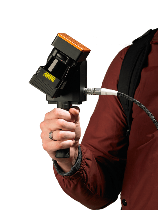
GeoSLAM’s portable technology, including the ZEB1 and the ZEB- REVO, changes the game entirely – providing home builders with three key benefits: speed, lower costs and increased flexibility. There are numerous advantages. Firstly, there is no need for specialized technicians – the ZEB-REVO is operational after just 2 button pushes, after which you simply walk and scan. The sheer speed of operation means that clients are finding the technology is up to 20x faster than traditional methods. GeoSLAM’s ZEB-REVO can rapidly scan rooms and multiple types of structures —an entire home in 30 minutes, and a large building in less than a day.
How does the ZEB-REVO work?
The difficult manual processes of measuring building structures are eliminated by using GeoSLAM’s ZEB-REVO lightweight, compact laser-scanner – which can be used in different configurations – either handheld, pole-mounted, or attached onto a mobile platform. The operator of the portable device simply carries it by hand, and walks through the environment to be scanned – be it a house, an office or a large building. The intelligent SLAM algorithm does the thinking, and once the scan is complete, the collected data is simply downloaded and processed. The end-result obtained from the data is a centimeter-grade 3D map, known as a point cloud, which can easily be imported into third party software to create 2D plans and layouts.
Additionally, GeoSLAM’s ZEB-REVO technology does not require a GPS signal — thus can scan any structure, enclosure or object, indoors our outside— anytime and anywhere — and it only requires one moderately trained person to use.
How much does it cost?
The ZEB REVO is approximately 1/3 the cost of a high resolution static scanner.